> For the complete documentation index, see [llms.txt](https://creating.toolkit.citiobs.eu/llms.txt). Markdown versions of documentation pages are available by appending `.md` to page URLs; this page is available as [Markdown](https://creating.toolkit.citiobs.eu/creating-and-running-a-citizen-observatory/i-want-to-work-with-data-by-integrating-data-from-several-citizen-observatories-other-sources.md).
# I want to work with data by integrating data from several Citizen Observatories/other sources
## Why is it relevant?
Some Citizen Observatories have regional and global coverage and impact, but these are the exception. Most commonly, Citizen Observatories engage a limited set of stakeholders and are localised in space and time, often focusing on a single topic. To generate a comprehensive overview of the issue and meaningful insights about your data, it is useful to combine variables and data from different Citizen Observatories and other citizen science projects in a single representation.
## How can this be done?
Data integration can be achieved by merging data from several projects into a single data set. However, this is only useful if the data are about the same issue (e.g. biodiversity spotting) and are collected in a semantically compatible way. A perfect example of such a centralised and systematic data collection system is that of the Global Biodiversity Information Facility (GBIF). The data compiled here are provided by many institutions and citizen science projects from around the world. GBIF’s information architecture makes these data accessible and searchable through a single portal. Data available through the GBIF portal are primarily distribution data on plants, animals, fungi and microbes. Two elements are key for this integration. The first is that a common set of scientific names and taxonomies has been adopted by the data sources (e.g. iSpot, iNaturalist, Pl\@ntnet, etc). This common taxonomy ensures that data from different sources has the same meaning and can be mixed together. The second element is an API provided by GBIF that facilitates data flows between the biodiversity Citizen Observatories and GBIF. This allows for the regular and automatic updating of the centralised dataset.
Data integration can also be done in an ad-hoc way. In this case, data is maintained in the original sources (the Citizen Observatory data services) and is presented together in a single view for comparison or analysis. This requires that users make the effort to interoperate with the data source using a tool that is able to do the integration on-the-spot. The [Open Geospatial Consortium (OGC)](https://www.opengeospatial.org/) and the WeObserve project are working on developing best practices on how to apply existing OGC standards for citizen science.
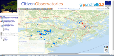
> ### Example from the GroundTruth 2.0 project
>
> 
>
> In the Ground Truth 2.0 project, seven observatories in six countries (Zambia, Kenya, Sweden, Spain, Belgium and The Netherlands) generated observations about biodiversity, natural resources, water management, water quality and air quality. The information from these observatories was presented together in a single map browser, using the OpenStreetMap data as a background. This enabled the complete set of observatories from a single point to be told in one comprehensive story.
The various Citizen Observatories and citizen science initiatives in place have led to the creation of a rather fragmented landscape of repositories, each with their resources available under different models, standards and technologies. In an effort to avoid silos of resources, the [Global Earth Observation System of Systems (GEOSS)](https://www.earthobservations.org/geoss.php) offers a single access point to [Earth Observation data](https://www.geoportal.org/), connecting users to various environmental monitoring systems around the world while promoting the use of common technical standards to support their GEOSS (see Portalwww\.geoportal.org). Similarly, the [European Open Science Cloud (EOSC)](https://www.eosc-portal.eu/) provides a virtual environment and a marketplace with open and seamless services for storage, management, analysis and re-use of research data. The [Cos4Cloud ](https://cos4cloud-eosc.eu/services/)project is developing and integrating the eleven services and resources in the European Open Science Cloud (EOSC) ecosystem, so that any existing citizen science observatory will be able to choose and install the technological services needed to improve its functionalities.
## Useful Resources
**WEBSITE**: The data from [**Ground Truth 2.0 Citizen Observatories**](http://www.ogc3.uab.cat/gt20/) is presented here in a single map that uses OpenStreetMap as a background and [**MiraMon**](https://www.miramon.cat/Index_usa.htm) technology as an engine.
**POLICY BRIEF**: This [**policy brief** ](https://zenodo.org/record/4001683#.YDjGPGhKguX)suggests a path toward the implementation of a shared computer infrastructure. It also recommends common services (e.g. authentication) that facilitate the efficient management of European Citizen Observatory sources, by making them reusable by current and future Citizen Observatory communities as well as making the activities and outputs of the communities visible in GEO.
## You may also be interested in:
[I want to work with data by collecting data](https://books.fablabbcn.org/creating-successful-and-sustainable-cos-toolkit/~/revisions/P2ESEVnb7x9THgs4UQg4/creating-and-running-a-citizen-observatory/i-want-to-work-with-data-by-collecting-data)
[I want to work with data by managing the data](https://books.fablabbcn.org/creating-successful-and-sustainable-cos-toolkit/~/revisions/P2ESEVnb7x9THgs4UQg4/creating-and-running-a-citizen-observatory/i-want-to-work-with-data-by-managing-the-data)
[I want to work with data by ensuring data quality](https://books.fablabbcn.org/creating-successful-and-sustainable-cos-toolkit/~/revisions/P2ESEVnb7x9THgs4UQg4/creating-and-running-a-citizen-observatory/i-want-to-work-with-data-by-ensuring-data-quality)
[I want to work with data by sharing our Citizen Observatory data](https://books.fablabbcn.org/creating-successful-and-sustainable-cos-toolkit/~/revisions/P2ESEVnb7x9THgs4UQg4/creating-and-running-a-citizen-observatory/i-want-to-work-with-data-by-sharing-our-citizen-observatory-data)
***
*This work by parties of the WeObserve consortium is licensed under a* [*Creative Commons Attribution-ShareAlike 4.0 International License*](https://creativecommons.org/licenses/by-sa/2.0/)*.*
---
# Agent Instructions
This documentation is published with GitBook. GitBook is the documentation platform designed so that both humans and AI agents can read, navigate, and reason over technical content effectively. Learn more at gitbook.com.
## Querying This Documentation
If you need additional information that is not directly available in this page, you can query the documentation dynamically by asking a question.
Perform an HTTP GET request on the current page URL with the `ask` query parameter, and the optional `goal` query parameter:
```
GET https://creating.toolkit.citiobs.eu/creating-and-running-a-citizen-observatory/i-want-to-work-with-data-by-integrating-data-from-several-citizen-observatories-other-sources.md?ask=&goal=
```
`ask` is the immediate question: it should be specific, self-contained, and written in natural language.
`goal` is optional and describes the broader end goal you are ultimately trying to accomplish on behalf of the user. GitBook uses it to tailor the answer towards what is most useful for that goal.
The response will contain a direct answer to the question and relevant excerpts and sources from the documentation.
Use this mechanism when the answer is not explicitly present in the current page, you need clarification or additional context, or you want to retrieve related documentation sections.